• A team discussing around media supports
    Outreach and Awareness raising

    This pillar is to ensure that adequate awareness and outreach activities are undertaken to better engage policymakers, administrators, entrepreneurs, scientists and civil society at all levels in using EO and geospatial data and information.

view

GMES and Africa Coordinator Addresses EO and Africa’s Develo…

The theme of the Summit was Digital Earth for Sustainable Development in Africa. GMES and Africa Coordinator and Space Science Expert at the African Union Commission, Dr. Tidiane Ouattara – who was the keynote speaker at the Summit, dwelt on how earth observation can contribute to the development of Africa through GMES and Africa.   Dr. Ouattara cited the vital…
view

Experiences and results of users of Earth Observation data f…

Experiences and results of users of Earth Observation data from Sentinel2 tabled for discussion among scientific and research communities in Rabat, Morocco.It was discussed during the international workshop on the Contribution of Sentinel2 Satellite Imagery for Research and applications for managing Environmental resources in Africa. The workshop ran from 06 to 08 February 2018, in Rabat, Morocco.GMES and Africa Support Programme is a pan-African Earth observation programme that uses Earth Observation data and information from Sentinel…
view

Establishment of Humanitarian and Early Warning Mechanisms i…

The African Union Commission and various stakeholders and partners have been discussing the establishment of integrated and continental Humanitarian and Early Warning Mechanisms in Africa, at a workshop which ran from 26 to 28 February 2018, in Nairobi, Kenya. The theme of the workshop was “African Union: A Decade of Humanitarian Action (2016-2025)”.The GMES & Africa Programme Coordinator and Space Science expert, Dr. Tidiane Ouattara, briefed participants on the potential contribution of Earth Observation through the GMES & Africa…
view

Marine User Handbook for Sentinel-3 users available online

A user guide that summarises  key information  required to enable both general users and technical  users to get information about marine altimetry products, from Sentinel-3 is made available online.The Marine User Handbook is produced by the EUMETSAT. The handbook describes available information on components of the altimetry system. It also discusses measurement techniques. The user Handbook is designed for current and potential users of Copernicus Marine Data Stream that are interested in the Sentinel-3 altimetry products for use in open…
view

Copernicus helps reduce the risk of coastal flooding and ero…

Conservation, management and restoration of ecosystems and vegetated foreshores can help reduce the risk of coastal flooding and erosion. Free and open data from Copernicus helps to monitor vegetation characteristics, wave attenuation, sedimentation and erosion.Data and information from Copernicus Programme offer a unique opportunity to deploy operational services that support more sustainable and cost-effective mitigation strategies.One of the thematic priorities of the Global Monitoring for Environment and Security and Africa (GMES &…
view

GMES & Africa discusses usage and applications of Copern…

Experts from Africa and Europe discusses how the Global Monitoring of Environment and Security & Africa Support Programme can adapt and use Earth Observation data from Sentinel satellites.The discussion is going on in a workshop organized by the Copernicus and the GMES & Africa programme for the upcoming three consecutive days (19-21 February 2018) in Accra, Ghana.GMES &Africa Support Programme is the African Union Commission’s Earth Observation flagship programme and the key component of the EU-AU Partnership (Lisbon, 2007) in the…
view

AUC Awards Thirteen Consortia of Institutions to Implement t…

The African Union Commission (AUC) officially awards grants to thirteen successful consortia of institutions that will serve as Regional Implementing Centres for the Global Monitoring for Environment and Security and Africa (GMES and Africa) Support Programme. Following a Call for Proposals in May 2017, a number of African institutions operating in the areas of …
view

GMES and AFRICA participates in the AfriCultuRes H2020 kick…

AfriCultuRes (African Agricultural Systems with the Support of Remote Sensing) is the Horizon 2020 project that won a call on using Earth observation (EO) technology for improving food security in Africa.The Project receives a four years' funding under grant agreement. It officially started on the 1st of November 2017 but hold its first meeting on 23-24/11 in Addis Ababa – The Hilton Hotel. AfriCultuReS will deliver a broad range of climatic, production, biophysical and economic information, for various regions in Africa by applying geospatial…
view

Earth Observation for the growth of Blue Economy in Africa

The possible contributions of Earth Observation applications for Blue growth in Africa under the GMES & Africa Support programme was tabled for discussionat the Africa GIS Conference, being held at the United Nations Economic Commission for Africa’s Conference Center, in Addis Ababa, Ethiopia. The Africa GIS 2017 Conference brings together policy makers, academia, private sectors, EO data providers and partners in the field of Earth Observation from Africa and the world.   In his keynote presentation the GMES & Africa Support…
view

Earth Observation for the Africa We Want

Invited to the AfricaGIS 2017 as a keynote speaker, the Coordinator of the GMES and Africa Support Programme underlined the significant role of Earth Observation and monitoring of Africa’s abundant natural resources in conserving the welfare of current and future generations.   The opening session of Africa GIS 2017 Conference started on 21 November 2017 in Addi…
view

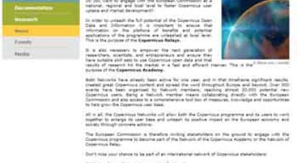
Join the Copernicus Academy and Relays Networks!

Do you want to engage with the European Commission at a national, regional and local level to foster Copernicus user uptake and market development? The Commission is launching a call for expression of interest to open two Copernicus Networks to new members... To unleash the full potential of the Copernicus Open Data and Information, the European Commission is run…
view

GMES and Africa is one of the keynote speakers in Africa GIS…

GMES & Africa Support Programme Coordinator, Dr Tidiane Ouattara is one of the keynote speakers in the upcoming Africa GIS 2017 Conference which will be held in Addis Ababa from 20 to 24 November 2017 under the theme: Geospatial and Statistical information imperatives for the ‘Africa We Want’.During the five day Africa GIS 2017 conference, leading scholars i…
view

Sentinel-2 cloudless mosaic: the first global (almost) cloud…

EOX IT Services, an Austrian Open Source solution provider for Earth Observation services, has implemented a methodical process crafting an almost cloudless Sentinel-2 map of the world   About 70 per cent of the Earth’s surface is covered by clouds any given day. Imagery obtained by satellite sensors operating in the visible light range is constantly constraine…
view

GMES and AFRICA participates in the AMCOMET Africa Hydromet…

This inaugural African Ministerial Conference on Meteorology (AMCOMET) – Africa Hydromet Forum was held in Addis Ababa to provide strategic insight towards Africa’s climate and disaster resilience through improvement of hydrological, meteorological and early-warning services.    Co-hosted by the African Union Commission and the Federal Democratic Republic of E…
view

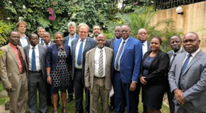
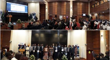
A key governance pillar of GMES and Africa holds its inaugur…

The GMES & Africa Policy Coordination and Advisory Committee (PCAC) has held its inaugural ordinary session in Abidjan, Côte d’ivoire, from 4 to 6 September 2017. PCAC is a key governance pillar of GMES & Africa.   Space is an important enabler for Africa’s sustainable development as well as for the advancement of Science and Technology on the continent…