• A team discussing around media supports
    Outreach and Awareness raising

    This pillar is to ensure that adequate awareness and outreach activities are undertaken to better engage policymakers, administrators, entrepreneurs, scientists and civil society at all levels in using EO and geospatial data and information.

view

Copernicus helps reduce the risk of coastal flooding and ero…

Conservation, management and restoration of ecosystems and vegetated foreshores can help reduce the risk of coastal flooding and erosion. Free and open data from Copernicus helps to monitor vegetation characteristics, wave attenuation, sedimentation and erosion.Data and information from Copernicus Programme offer a unique opportunity to deploy operational services that support more sustainable and cost-effective mitigation strategies.One of the thematic priorities of the Global Monitoring for Environment and Security and Africa (GMES &…
view

GMES & Africa discusses usage and applications of Copern…

Experts from Africa and Europe discusses how the Global Monitoring of Environment and Security & Africa Support Programme can adapt and use Earth Observation data from Sentinel satellites.The discussion is going on in a workshop organized by the Copernicus and the GMES & Africa programme for the upcoming three consecutive days (19-21 February 2018) in Accra, Ghana.GMES &Africa Support Programme is the African Union Commission’s Earth Observation flagship programme and the key component of the EU-AU Partnership (Lisbon, 2007) in the…
view

Sentinel monitors Harmful Algal Blooms

When colonies of microscopic algae grow out of control in the water bodies, Harmful Algal Blooms (HABs) can occur. HAB produce toxins that cause massive fish deaths, poison shellfish beds, and contribute to human illness and death. Thanks to Sentinel-3's , it is possible to track HABs.Sentinel-3's Ocean and Land Colour Instrument (OLCI) sees and detect Harmful Algal Blooms (HABs) by using ocean color measurements.OLCI allows biogeochemical measurements like concentrations of Chlorophyll a — the photosynthetic pigment of phytoplankton (algae…
view

ESA provides Earth Observation data from non-ESA missions to…

ESA and GAF have extended their agreement about the provision of IRS data and DSMs as Third Party Mission (TPM) data to scientific users until end 2018 or until full consumption of the budget, whichever occurs first. Depending on the scientific relevance of their proposals, ESA will grant scientists free-of-charge access to IRS optical HR/MR satellite imagery and…
view

A year of achievements and Copernicus plans for 2018

If 2017 has been a landmark year in the history of the Copernicus programme, more will come in 2018. In an Editorial published on 12/01/2018, Philippe Brunet, Director for Space Policy Copernicus and Defence at EC's DG GROW explains.The offer of products and services has dramatically increasedThere is now over 743 Copernicus information products – actio nable geoinformation and intelligence - that are available from Copernicus for the support of environmental security and policies. And there is six core Copernicus services impacting citizens…
view

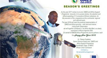
GMES and AFRICA Season's Greetings / Meilleurs Voeux

As the year 2017 comes to an end, GMES and Africa Support Programme recounts in its success stories, the selection and official awarding of 13 consortia of African institutions, for the execution of the programme at the continental, regional and national levels. The year 2018 will mark the practical implementation of GMES and Africa services – both land and marin…
view

GMES & Africa's capacity development training works…

The Global Monitoring for Environment and Security and Africa (GMES and Africa), kick starts capacity development training workshop for the thirteen consortia of institutions that have been officially awarded grants to implement the GMES & Africa at regional level in Africa. The overall objective of the training workshop, that runs from 29 November to 01 D…
view

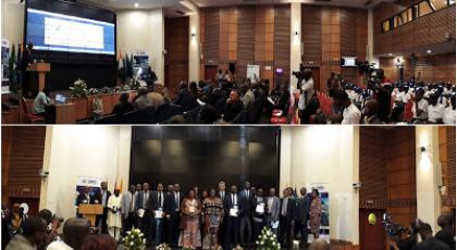
AUC Awards Thirteen Consortia of Institutions to Implement t…

The African Union Commission (AUC) officially awards grants to thirteen successful consortia of institutions that will serve as Regional Implementing Centres for the Global Monitoring for Environment and Security and Africa (GMES and Africa) Support Programme. Following a Call for Proposals in May 2017, a number of African institutions operating in the areas of …
view

GMES and AFRICA participates in the AfriCultuRes H2020 kick…

AfriCultuRes (African Agricultural Systems with the Support of Remote Sensing) is the Horizon 2020 project that won a call on using Earth observation (EO) technology for improving food security in Africa.The Project receives a four years' funding under grant agreement. It officially started on the 1st of November 2017 but hold its first meeting on 23-24/11 in Addis Ababa – The Hilton Hotel. AfriCultuReS will deliver a broad range of climatic, production, biophysical and economic information, for various regions in Africa by applying geospatial…
view

Get trained to Radar Remote Sensing with ESA ECHOES in Space

Echoes from space can take you on a journey through the exciting world of Radar Remote Sensing. The learning is self-paced. Registration is open during all the course. You can also pick up learning when the time is right for you.EO College is developed by the Friedrich-Schiller University in Jena, Germany and is sponsored by ESA. With ECHOES you can learn the basics that will help you to understand where this technology is coming from, how the images are acquired and which manifold applications already use Radar Remote Sensing to help protect…
view

Earth Observation for the growth of Blue Economy in Africa

The possible contributions of Earth Observation applications for Blue growth in Africa under the GMES & Africa Support programme was tabled for discussionat the Africa GIS Conference, being held at the United Nations Economic Commission for Africa’s Conference Center, in Addis Ababa, Ethiopia. The Africa GIS 2017 Conference brings together policy makers, academia, private sectors, EO data providers and partners in the field of Earth Observation from Africa and the world.   In his keynote presentation the GMES & Africa Support…
view

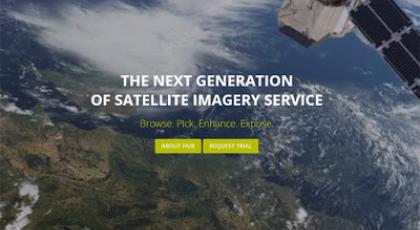
Sentinel hub - 1 year free earth observation data

ESA has partnered with Sentinel Hub to offer your business 1 year free and easy access to a wide range of EO data and 10 hours of support to help you build new services.Sentinel Hub is a simple and efficient way of archiving, processing and distributing satellite data using standard web services that can be easily integrated in any desktop, web or mobile mapping …
view

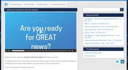
The Copernicus Research and User Support (RUS) Service porta…

The RUS Service is the “New Expert Service for Sentinel Users” funded by the European Commission, managed by the European Space Agency, and operated by CS SI and its partners. The main objectives of the RUS Service are:   To promote the uptake of Copernicus data; To support the scaling up of R&D activities with Copernicus data. To fulfil these objectives, t…
view

Earth Observation for the Africa We Want

Invited to the AfricaGIS 2017 as a keynote speaker, the Coordinator of the GMES and Africa Support Programme underlined the significant role of Earth Observation and monitoring of Africa’s abundant natural resources in conserving the welfare of current and future generations.   The opening session of Africa GIS 2017 Conference started on 21 November 2017 in Addi…
view

ICT based tools of MESA transferred to GMES and Africa

Following a series of consultations in the last six months between the two Programmes, ICT based tools of MESA have been transferred to GMES & Africa The Monitoring for Environment and Security in Africa (MESA) was a joint AU-EU programme which has been in operation in the area of Earth Observation (EO) for the past four years. The Programme is now officially…